It is almost a third of the way through April and we are celebrating the fact that today there is wall to wall sunshine and a temperature of - wait for it - 8 degrees. Compared with March that is positively balmy, but this time last year the landscape had already started to come to life. The daffodils and crocuses had given us a fine show, the first of the bluebells were starting to appear, and the scenery had that fresh, spring feel to it. Today the Lake District is still wearing it's winter coat. The snow capped mountains look lovely, but how we all long for the fresh green leaves to appear.
I took advantage of the weather this afternoon to do a walk that is a joy at any time of year, - Holme Fell, with a return via Tarn Hows. However, instead of publishing the pictures of today's walk, I've delved into the archive and dug out some pictures from a previous visit over the same route in August 2007.
We started from the car park at the bottom of Tom Gill, just beyond Yew Tree Tarn on the A593 Ambleside to Coniston Road. To avoid the road, the first part of the walk is through an adjoining field, and at the other end one of the locals decided that we were not allowed to go any further!
After tough negotiations during which I had to give up part of my sandwich, we were allowed to pass, and crossed the road to Yew Tree Farm.
From the farm we headed along a farm track, before going through a gate and then following a path along the side of the fell. After a short distance this rock (below) was reached. Not being a geologist I have no idea why it stands here. My worn out old copy of Pearsall and Pennington's excellent book on the Lake District has no mention of it. An amateur geologist friend of mine claimed it was due to erosion causing a large lump of rock to break off the crags above and roll down the fell side. I'm not so sure about that, so answers on a post card please
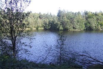
Just beyond the rock, we get a lovely view of Yew Tree Tarn, which is a popular spot for passing motorists to stop and admire. We waved, but no one waved back!!
Not far past the rock the path bears left and starts to climb the wooded fell side. Before long we come across a beck and follow the line of it up the fell. It's not too steep and luckily carries barely a trickle of water. After reaching the top of the slope we bear left again to clamber up the craggy fell to the summit, where a superb view of Coniston Water awaits.
One very noticeable feature of this trip was the abundance of wild heather, coupled with a lack of sheep. The two are linked, since the sheep are more than happy to munch away on the heather, however, the absence of sheep on the fell at this time is an indication that when left alone the heather recovers nicely.
From the top of Holme Fell, Coniston Water is not the only key landmark to be seen. To the north lie the Langdales, with the pikes prominent on the horizon.
We are not returning via the same route. Instead we are heading down the fell towards Hodge Close Quarry, where we can join up with the Cumbrian Way for a short distance. Being a couple of total sissies, we keep well away from the edge! Out of camera, a party from an outdoor pursuits centre are abseiling down the old quarry walls. From the sound of it, they are having no end of fun.
There's a bit of road walking now, along a minor road leading to a farm, and offering superb views of the fells over the wall!
We soon reach the main A593, and cross over to take the short road up to a gate leading to the track to Tarn Hows. This is not only a popular route for walkers, but also mountain bikers, who like to test their skills on the rocky path. Today however, despite it being the middle of the holiday season, there is no one else in sight.
Tarn Hows is not so peaceful, with families enjoying the fine August weather. That having been said, there is plenty of space for everyone, so it is not difficult to take a picture that makes it look as though we have the place to ourselves.
From Tarn Hows we head down a footpath following the line of Tom Gill, the beck that drains the tarn.
Nowadays this is known as "Glen Mary", after the wife of James Marshall, the man who first developed Tarn Hows by damming the stream at the top of Tom Gill to make one large tarn from three smaller ones. It is reputed that John Ruskin was responsible for persuading Marshall that the name Tom Gill was not suitable for a place of such beauty, and suggested the name "Glen Mary" instead. Whether the story is actually true or not remains open to speculation. Marshall died in 1873, not long after Ruskin moved to Brantwood.
Midway down the slope is "Glen Mary" waterfall, which, because the flow of the beck is controlled by the dam at the tarn, always seems to have roughly the same amount of water flowing over it.
From the falls, it is a short distance down the hill to a bridge at the bottom, and beyond, the main road, the car park, and a freshly brewed cup of tea.
Roll on Summer!!!